

Selkirk Copper Completes Phase 1 Drill Program and Assumes Site Responsibility for Minto Copper-Gold-Silver Mine
Press Release
Highlights
- Selkirk Copper has successfully completed its Phase 1 drill program, comprising 52,288 m of drilling in 175 holes. This represents one of the largest drilling programs completed in Yukon in the last ten years.
- The drill program, employing four (4) diamond drills, was completed safely with zero medical aid or lost time injuries. The program was completed on-schedule with high productivity averaging 94 metres per day per drill, and relatively low cost-per-metre.
- Resource expansion and exploration drilling had a high rate of success with 87% of holes intersecting one or more mineralized lenses of significant grade and thickness. Assay results have been released for 48% of the Phase 1 drill program, with outstanding assays expected to be released over the next two months.
- As of April 1, 2026, Selkirk Copper assumed responsibility for site operations, including care and maintenance activities. Selkirk Copper expects to undertake several project readiness activities ahead of a potential restart decision in mid-2027.
Leadership Team Update
- We are pleased to announce the appointment of Shiro Rae as Director, Business Planning and Site Operations who will direct and support all aspects of Selkirk Copper’s site-based work programs including safety, camp operations, environment, care and maintenance, and exploration and resource drilling program working closely with Selkirk Copper’s leadership team.
April 15, 2026 – Vancouver, BC and Pelly Crossing, YT – Selkirk Copper Mines Inc. (TSX-V:SCMI | FRA:IO20 | OTCQB:SKRKF) (“Selkirk Copper” or the “Company”) is pleased to announce completion of the Phase 1 drill program, and assumption of responsibility for site operations at the Minto Mine in Yukon, Canada.
M. Colin Joudrie, President & CEO, commented: “With the successful completion of the Phase 1 drill program, I want to extend sincere thanks to the Selkirk Copper exploration team, our exploration contractors including Omineca Drilling, and the Selkirk First Nation for all of their hard work. With drilling now completed we expect a steady flow of assay results from the Phase 1 drill program, that we will continue to release through the end of May, which will inform an updated Mineral Resource Estimate and a Preliminary Economic Assessment that is on schedule for completion by mid-2026.
“We are also pleased that Selkirk Copper has taken over responsibility for operations of the Minto Mine site. This marks an important milestone as the site transitions away from a focus on care and maintenance, towards resource expansion, engineering and trade-off studies, and site-wide technical data collection, to inform a potential restart decision in mid-2027.
“I would like to welcome Shiro Rae to the team. Shiro’s leadership and experience managing large scale project activities with complex camp and site operations in the NW of British Columbia along with his experience working directly with First Nation Communities, First Nation Development Corporations, and local suppliers and service providers, will greatly assist Selkirk Copper’s restart planning activities.”
2025-2026 Phase 1 Drill Program
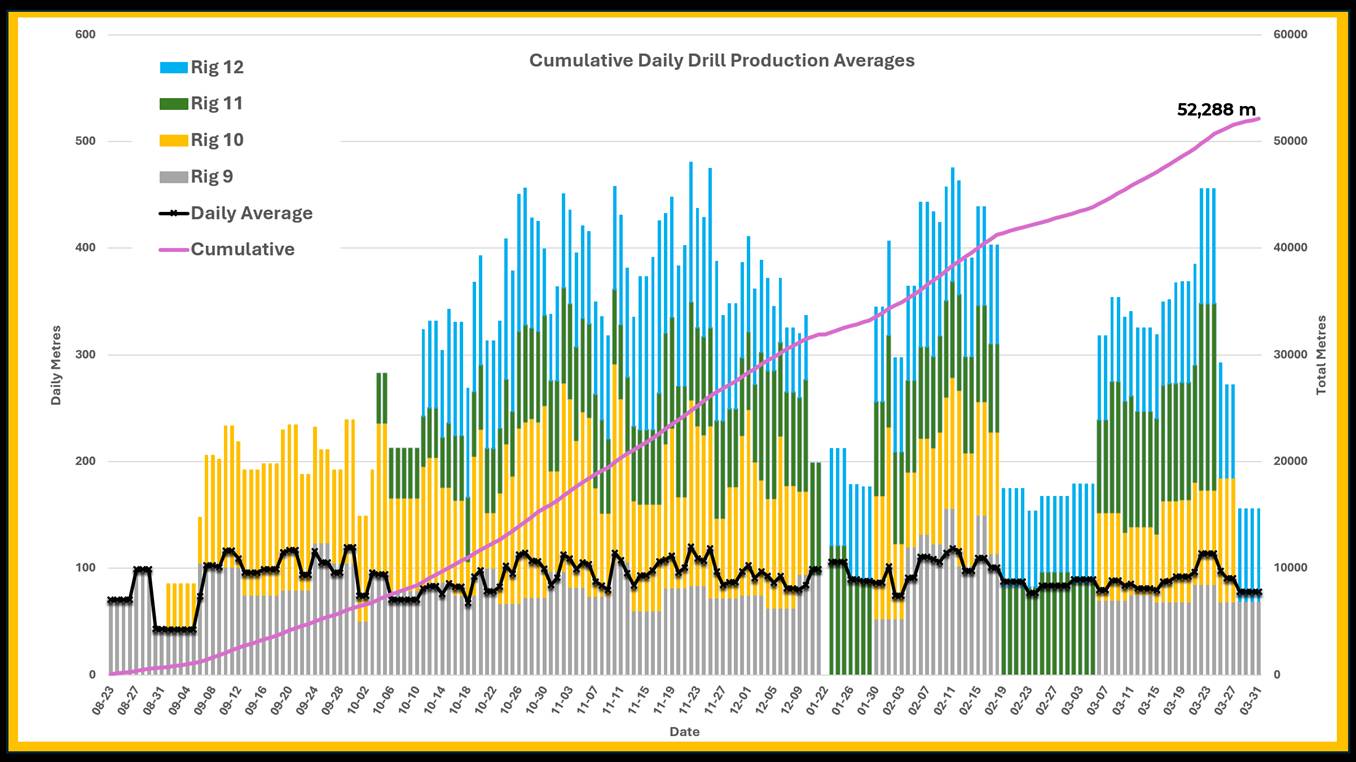
The Phase 1 drill program was conducted between August 2025 and March 2026 with four diamond drill rigs. Drilling was continuous throughout this time, except for a six-week break during December to January when winter temperatures on site reached as low as -55°C. Drilling was completed safely, with no medical aid or lost-time injuries, and minimal downtime. Drilling productivity was very high, including individual drills producing more than 200 metres per day in some instances, with an average of 94 metres per day per drill throughout the entire program (Figure 1). High productivity and relatively low cost-per-metre enabled surpassing of the originally planned 50,000 m program, resulting in completion of 52,288 metres representing 105% of the initial plan.
On-site activities related to the Phase 1 drill program, including core logging, cutting, and sampling, are expected to be completed before mid-April. Outstanding assay results are expected to be received and released over the next two months, with approximately 48% of the drill results reported to-date. Geological modelling is underway to incorporate drill results into the updated mineral resource estimate (MRE) which is expected to be completed in June 2026.
Results from the Phase 1 drill program and updated MRE will be used to support a Preliminary Economic Assessment (PEA), which is scheduled for completion in mid-2026. Technical studies, engineering designs, and mine plan scheduling to support the PEA are advancing as planned.
Figure 1: Summary of metres drilled by drill rig, highlighting the measured ramp up starting in August to our full production in October. The strong daily average production of 94 m/day enabled a completion of 105% of planned metres for a total of 52,288 m.
Table 1: Phase 1 Drilling by Zone
| Zone | Holes completed | Metres drilled |
| Minto North | 43 | 13,613 |
| Ridgetop | 68 | 13,940 |
| Minto East | 23 | 9,952 |
| Copper Keel | 10 | 3,475 |
| 118 | 19 | 5,648 |
| Minto Main | 12 | 5,660 |
| Total | 175 | 52,288 |
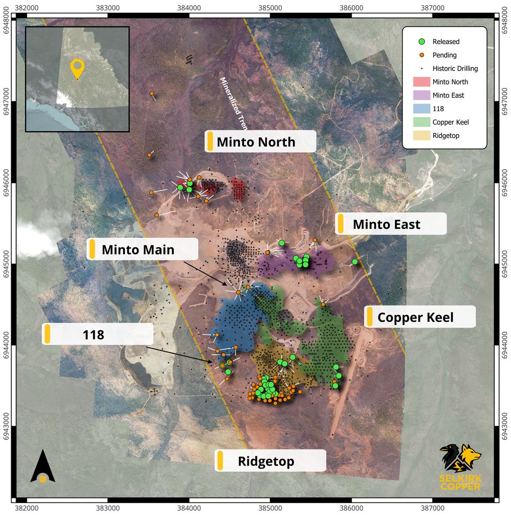
Figure 2: Plan view of the Minto Mine showing surface projections of mineralized zones (Ridgetop (yellow), Copper Keel (green), 118 (blue), Minto East (purple) and Minto North (red)), relative to Phase 1 drill collars (orange and green circles).
Phase 1 Drill Program Highlights
The Phase 1 Drill Program targeted resource expansion in six locations within the Minto mine area. In each location, resource expansion drilling stepped-out along sub-horizontal mineralized lenses at varying distances ranging from 40 to 80 metres per hole. Drill plans and priorities evolved iteratively, with early results guiding subsequent work. Significant extensions to mineralized lenses were identified in several areas, most notably Minto North, Ridgetop and Minto East.
Success for resource expansion drill holes was evaluated based upon grade and thickness of mineralized lenses that were intersected within each drill hole. Some holes intersected multiple stacked lenses of mineralization, producing several significant intercepts for each drill hole. Copper grades from assays released in the first half of the Phase 1 drill program correlate well with visual logged estimates of bornite and chalcopyrite mineralization. Based upon available assays and visual logged estimates, approximately 87% of Phase 1 drill holes are considered to have intersected notable mineralization, although assay results for the second half of the drill program are still pending.
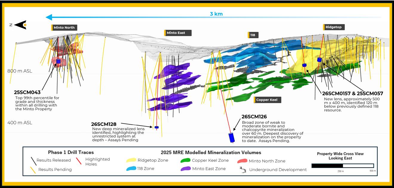
Highlights from resource expansion drilling (Figure 3) include expansion at the Minto North west zone which is estimated to have increased at least two times from the 2025 MRE modelled volume. Drilling in the Minto North west zone returned very high grades in multiple drill holes including 25SCM043 (see previous release on February 19, 2025). This drill hole intersected 3.52% Cu, 3.51 g/t Au and 17.04 g/t Ag (6.3% CuEq) over 16.7 m, within a broader zone of 2.09% Cu, 1.84 g/t Au and 9.48 g/t Ag (2.9% CuEq) over 32.9 m. This result is within the top 99th percentile of grade and thickness for all drilling within the Minto database, which spans six decades and includes more than 1,400 drill holes and more than 4,300 significant intercepts. Additional assay results are pending from the Phase 1 drill program at Minto North, and the mineralized lens remains open to the south and will be a priority for further follow-up during the Phase 2 drill program.
Figure 3: Global long section looking East, highlighting holes 25SCM043, 26SCM128, 26SCM126, 26SCM157 and 25SCM057 as discussed in text.
The Phase 1 Drill Program also included more aggressive exploration drilling, including larger step-outs, targeting of untested geophysical anomalies, and targeting of new mineralized lenses at depth beneath known resource areas. Geophysical targeting was guided from a compilation of known and available property-wide geophysical data sets linked to the observed geology and associated mineralogy. The team continues to develop a deeper understanding of the lithological and mineralogical characteristics of the mineralized zones and how they relate to geophysical anomaly intensities most closely associated with copper-gold mineralization including moderate-to-high chargeability, low resistivity, and high magnetic intensity. Exploration targeting has also been guided by deposit model criteria that were developed during the Phase 1 drill program, including understanding of structural controls, mineralized trends, and sulphide zonation.
Highlights from exploration drilling include discovery of a new mineralized lens in Area 118 approximately 120 metres below the previously known resource. Results from this new lens include drill hole 25SCM057 which intersected 0.76% Cu, 0.42 g/t Au, and 3.56 g/t Ag (1.15 % CuEq) over 29.7 m (see previous release on March 25, 2026). Subsequent exploration drilling has delineated this new lens over an area approximately 500 x 400 metres. Assay results are still pending for several drill holes in this area, including 26SCM157 which intersected a 14-metre interval containing disseminated bornite and chalcopyrite (Figure 4). This newly discovered lens remains open in several directions and will be a priority for further follow-up drilling during the Phase 2 drill program.
Additional highlights from exploration drilling in the Phase 1 drill program include several of the deepest intercepts of mineralization that have been drilled at Minto over sixty years of previous work. Assay results are still pending for several deep drill holes, including 26SCM126 beneath Minto Main which intersected sparsely disseminated bornite-chalcopyrite mineralization over 60 m from 720-787 metres downhole; and 26SCM128 in Minto East which intersected a 10-metre interval containing bornite and chalcopyrite at a depth of 650 metres downhole. Both of these drill intercepts are indicative that mineralization remains open at depth beneath the limits of previous drilling and in several directions. Additional exploration drilling into these areas is proposed once access to the underground has been re-established.
Figure 4: Detail photograph of semi-massive bornite and chalcopyrite mineralization in recently discovered mineralized lens located 120m below the Area 118 resource zone. This photograph is from within a 14-metre interval with visible sulphides. Assay results for this hole are pending.
Assumption of Mine Site Responsibilities
On April 1st, 2026, Selkirk Copper assumed additional responsibilities for care and maintenance of the Minto mine site from the Yukon Government Ministry of Energy, Mines and Resources, as outlined in the Framework Agreement that has been established between Selkirk Copper, the Selkirk First Nation, and the Yukon Government.
Selkirk Copper has entered into a number of agreements and contractual arrangements with appropriate service providers to position the company to assume these additional responsibilities for the site, as well as to support a restart decision. These include agreements and contractual arrangements related to management, accounting, legal, risk, operations, concentrate marketing, financing advisory services, corporate marketing, corporate services, port services, and generalized technical, operational, environmental, and socio-economic activities specific to mine development, mine financing, mine operations, and mine closure.
Selkirk Copper has also entered into employment contracts with supervisors, medics, safety personnel, electrician, millwrights, heavy equipment operators, cooks, cleaners, laborers, and support staff all of whom are familiar with a range of site activities.
Leadership Team Update
We are pleased to announce that Shiro Rae has joined Selkirk Copper’s leadership team as Director, Business Planning and Site Operations. Mr. Rae is a geoscientist and economist and brings over 17 years of experience working in the natural resources industry across greenfield and brownfield exploration, project development, site operations, business planning and investor relations. His career spans copper, gold, and base metal projects across British Columbia, the southwestern United States, and Australia, with a particular focus on copper-gold porphyry systems.
Prior to joining Selkirk Copper, Mr. Rae spent a decade working with Teck Resources Limited holding progressively senior technical and leadership roles. Most recently, he served as Manager of Business Planning and Manager of Field Operations at Galore Creek Mining Corp., where he helped advance the project through prefeasibility stage, and led complex multidisciplinary field programs with a strong focus on safety, operational excellence, and responsible resource development in alignment with community and First Nation priorities.
Mr. Rae holds a B.Sc. (Honours) in Geology and a B.A. in Economics from the University of British Columbia.
QAQC Procedures and Data Validation
The Company is drilling NQ sized core. Following data collection, core is cut along the long axis, with half of the core going to the lab for chemical analysis and the remaining half kept in sequence as record. The half core samples are packaged with the corresponding sample tag id and sealed. All sampling is conducted by Selkirk Copper Mines Inc. and subject to Company standard internal quality control and quality assurance (QAQC) programs which include the insertion of certified reference material, coarse blank materials, and field duplicate analysis, on top of the standard laboratory QAQC procedures to monitor contamination during preparation and analytical accuracy and precision. QAQC insertion rates approximate 15% of all samples at set intervals. For the 2025 program all samples were sent to ALS Laboratory’s prep laboratory in Whitehorse, YK, then shipped to ALS Vancouver for gold fire assay and four-acid multi-element analysis. All samples are prepared by crushing rock to 70% passing 2mm screen, then splitting a 250g sub-sample using a riffle splitter before being pulverized 85% passing 75 microns. Gold is analyzed by 30 g Fire Assay (Au-AA23) with atomic absorption (AAS) analysis followed by gravimetric finish for overlimit results. Copper is analyzed by four-acid digest (ME-ICP61) with inductivity coupled plasma – atomic emission spectroscopy (ICP-AES) finish. If Cu overlimit results are triggered a second four-acid digest for high grade copper (Cu-OG62) is conducted. For any samples where oxide copper minerals are identified, a sulphuric acid leach (Cu-AA05) analysis with AAS finish is performed. ALS Vancouver holds an ISO/IEC 17025 standard accreditation.
QAQC results are reviewed open receipt of results. Overall QAQC results show strong analytical performance across Cu, Au, and Ag datasets. All control standards are within acceptable tolerance, with no significant outliers or systematic bias observed.
Primary intervals are reported as drill core length, with true widths estimated to be approximately 90% of core lengths, based on the sub-horizontal to shallow-dipping nature of the modelled mineralized zones.
Mineral Resource Estimate Details
The following table summarizes the current Minto Mineral Resource Estimate:
Table 2: Global Mineral Resource Estimate for the Minto Project (Effective Date: April 7, 2025)
The MRE has been completed by Sue Bird of Moose Mountain Technical Services (MMTS).Resources are reported using the 2014 CIM Definition Standards and were estimated using the 2019 CIM Best Practices Guidelines.Mineral Resources that are not Mineral Reserves do not have demonstrated economic viability.Metal prices of US$2000/oz Au, US$23/oz Ag, US$4.00lb Cu.For the NSR calculations: a currency exchange rate of 0.72 US$ per C$; 95% payable Cu, 88% payable Au and 70% payable Ag; offsite costs (refining, transport and insurance) of US$256.18/dmt; royalties of 1.5% NSR.Recoveries are as follows:CuRec = 95.5%+1.07*Cu%-113*ASCu/TCu, with a maximum of 98%AuRec = 20.99*Augpt + 62.01, with a maximum of 95%AgRec = 69.4+1.9*Aggpt, with a maximum of 85%These inputs result in the following NSR and CuEq equations respectively: NSR = C$4.73*CuRec*Cu%*22.0462 + (C$2400.60*AuRec*Augpt + C$21.45*AgRec*Aggpt)/31.10348
CuEq = NSR/(Cu*CuRec*22.0462) The Mineral Resource has been confined by a “reasonable prospects of eventual economic extraction” pit or underground shape using the 100% base case NSR for the Ridgetop and Area 118 open pits and by a confining shape for the underground.Mining costs are C$4.10/tonne for open pit, C$45.42/tonne for underground, Processing costs are C$30/tonne milled and G&A costs are C$20.81/tonne milled.Pit slope angles are assumed at 45º.The specific gravity of the deposit has been assigned based on domain as between 2.578 and 2.849 based on sg measurements in the Minto deposit.Ox Ratio = ASCu/Total Cu.Numbers may not add due to rounding.OP denotes Open Pit; UG denotes Underground
| Type | Cut | Class | ROM | In Situ Grade | Metal | |||||||
| (CDN$) | Tonnage (000) | NSR (CDN$) | Cu (%) | Au (gpt) | Ag (gpt) | Ox Ratio | ASCu (%) | Cu (Mlbs) | Au (Koz) | Ag (Koz) | ||
| OP | $30 | Indicated | 6,085 | $89.11 | 0.897 | 0.274 | 2.9 | 0.15 | 0.163 | 120.3 | 53.7 | 560.4 |
| Inferred | 9,496 | $73.71 | 0.702 | 0.162 | 2.4 | 0.07 | 0.057 | 146.9 | 49.3 | 738.4 | ||
| UG | $80 | Indicated | 6,504 | $183.90 | 1.489 | 0.636 | 5.6 | 0.06 | 0.090 | 213.5 | 132.9 | 1,167.6 |
| Inferred | 14,162 | $156.85 | 1.281 | 0.539 | 4.9 | 0.06 | 0.075 | 399.9 | 245.4 | 2,229.6 | ||
| Total | Varies as Above | Indicated | 12,588 | $138.08 | 1.203 | 0.461 | 4.3 | 0.10 | 0.125 | 333.8 | 186.6 | 1,728.0 |
| Inferred | 23,658 | $123.48 | 1.048 | 0.387 | 3.9 | 0.07 | 0.068 | 546.8 | 294.7 | 2,968.1 | ||
| Notes | ||||||||||||
References
1 See 2025-08-06 Technical Report “NI 43-101 2025 Mineral Resource Estimate Update for the Minto Property, Yukon, Canada” effective date 2025-04-07 filed by Venerable Ventures Ltd., available on SEDAR+ (sedarplus.ca).
Technical aspects of this news release have been reviewed, verified and approved by Stacie Jones-Clark, P.Geo., Vice President Exploration of Selkirk Copper Mines Inc., who is a qualified person as defined by National Instrument 43-101 – Standards of Disclosure for Mineral Projects.
About Selkirk First Nation
Selkirk First Nation is centered in Pelly Crossing, a community in central Yukon, 280km north of Whitehorse. They are a self-governing First Nation, having signed its Final and Self-Government Agreements in 1997. Selkirk owns 4,740 square kilometers of Settlement Land, including 2,408 square kilometers where Selkirk owns both the surface and subsurface. Selkirk First Nation is one of three self-governing Northern Tutchone First Nations in the Yukon. The Selkirk First Nation, indirectly, holds a controlling equity stake in Selkirk Copper.
About Selkirk Copper
Selkirk Copper is a well-financed, newly formed company with a controlling interest held by the Selkirk First Nation through its wholly owned subsidiary, that, in partnership with the Selkirk First Nation, is completing a thorough exploration drilling campaign and a restart and redevelopment plan for the former Minto copper-gold-silver mine based on best-in-class environmentally sustainable mining, development and reclamation practice. Selkirk Copper controls 26,850 hectares of prospective mineral claims located in the Minto-Carmacks copper belt as well as significant open-pit and underground infrastructure, a 4,100 tonne per day processing plant, 400-person full-rotation camp, water treatment facilities, numerous ancillary buildings, and mobile equipment centered on the former Minto copper-gold-silver mine. Selkirk Copper’s mineral tenure, operation infrastructure, access roads and powerline, is located on or adjacent to Lands of the Selkirk First Nation much of which is surrounded by prospective Selkirk First Nation Category A Lands.
Selkirk Copper Mines Inc. is listed on the TSX Venture Exchange under the symbol TSX-V:SCMI, has a secondary listing on the Frankfurt Exchange under the symbol FRA:IO20, and its common shares trade under the symbol OTCQB:SKRKF on the OTCQB® Venture Market, a U.S. marketplace operated by OTC Markets Group Inc.
On behalf of the Board of Directors of Selkirk Copper Mines Inc.
M. Colin Joudrie
President and Chief Executive Officer
For more information, please contact:
M. Colin Joudrie, President & CEO
colin.joudrie@selkirkcopper.com
(604) 760-3157
Justin Stevens, Vice-President Corporate Development
justin.stevens@selkirkcopper.com
(604) 240-2959
ILR4


