

Blue Star Updates its Ulu Gold Project Mineral Resource Estimate
Press Release
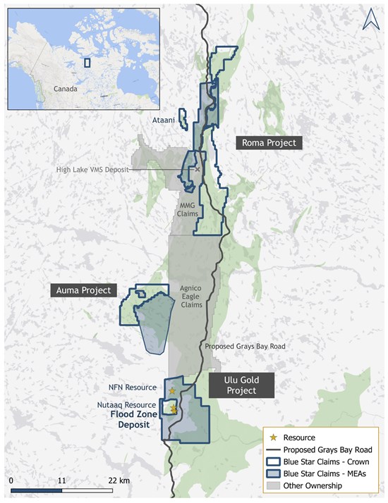
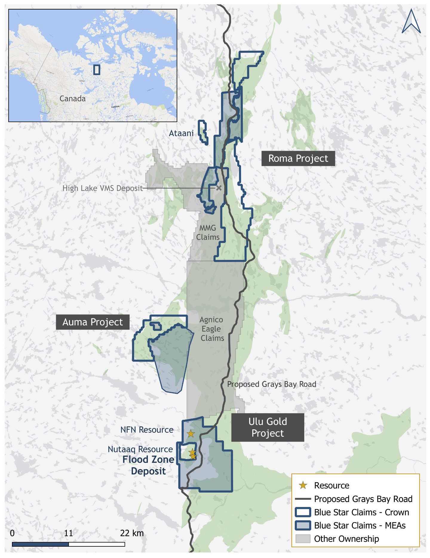
Vancouver, British Columbia–( – May 21, 2026) – Blue Star Gold Corp. (TSXV: BAU) (OTCQB: BAUFF) (FSE: 5WP0) (“Blue Star” or the “Company”) announces an update to the Company’s Mineral Resource Estimate (“MRE”) for the Ulu Gold Project (the “Project”) in the High Lake Belt, West Kitikmeot Region, Nunavut, Canada. The MRE conceptualizes potential open-pit and underground approaches to the Mineral Resource located within 1,500 metres of the proposed Grays Bay Road Project (Figure 1).
Highlights
- Measured and Indicated Mineral Resource of 2.204 million tonnes at an average grade of 7.87 grams per tonne (“g/t”) gold (“Au”) for 558,000 ounces of gold
- Inferred Mineral Resource of 3.263 million tonnes at an average grade of 4.54 g/t Au for 476,000 ounces of gold
- Existing metallurgical studies suggest that all zones within the MRE could potentially be co-processed, achieving gold recoveries exceeding 90%
- Gold mineralization remains open to further expansion across all contributing zones
- The numerous gold showings and underexplored zones across the Company’s district-scale projects present strong potential for expanding its Mineral Resource base
Blue Star’s CEO, Grant Ewing, commented, “This updated Mineral Resource Estimate highlights the strength and growth potential of the Ulu Gold Project amid strong gold prices and ongoing support for the proposed Grays Bay Road and Port Project. The higher-grade Measured and Indicated Mineral Resource, combined with an increase in Inferred ounces, further reinforces the Project’s potential for continued Mineral Resource expansion. This potential is supported by numerous high-quality Exploration Targets across the Company’s extensive land package.”
Updated Ulu Mineral Resource Estimate
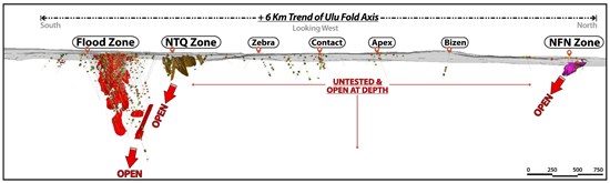
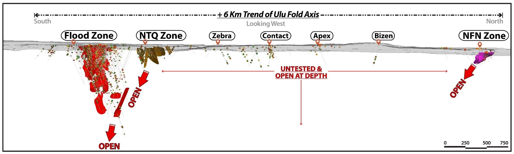
P&E Mining Consultants Inc. was contracted to update Blue Star’s 2023 Mineral Resource Estimate for the Ulu Gold Project. The updated MRE is based on 574 diamond drill holes totalling 123,004 metres spanning over thirty years to the present along and adjacent to the Ulu Fold Hinge (Figure 2). Blue Star has completed 125 of these drill holes totaling 23,185 metres since 2019.
The updated MRE incorporates revised geological interpretations and updated cut-off grades, reflecting higher assumed gold prices and operating costs. These assumptions have been applied to constrain the Mineral Resources and have resulted in lower cut-off grades. Mineralized domains were initially developed by Blue Star and subsequently reviewed, modified, and validated by P&E using Leapfrog Geo™ software. Block model grade estimates were constrained by these geological interpretations and were completed using a multi-pass inverse distance cubed (“ID3”) interpolation methodology applied to capped 1.0 metre composites in GEMS™ software. Open Pit Mineral Resources were constrained within optimized pit shells generated using NPV Scheduler™ software, with consideration of reasonable prospects for eventual economic extraction, including assumptions regarding potential underground mining. Underground Mineral Resources were constrained using optimized stope shapes generated with Deswik™ software, applying a minimum mining width of 1.5 metres and a cut-off grade of 2.0 g/t Au, and restricted to areas demonstrating geological continuity. A 2-metre external buffer was applied to mineralized wireframes to account for marginal material and internal dilution during underground stope optimization. All blocks contained within the optimized underground stope shapes have been included in the MRE at a zero-cut-off grade.
Table 1: Ulu Gold Project Mineral Resource Estimate.
| Resource Type | Zone | Classification | Cut-off Au g/t |
Tonnes (k) |
Au (g/t) |
Contained Au (koz) |
| Pit Constrained | Flood | Measured | 0.8 | 441 | 8.33 | 118 |
| Indicated | 0.8 | 200 | 6.95 | 45 | ||
| M+I | 0.8 | 641 | 7.90 | 163 | ||
| Inferred | 0.8 | 142 | 4.32 | 20 | ||
| NTK | Indicated | 0.8 | 2 | 8.04 | 1 | |
| Inferred | 0.8 | 90 | 4.07 | 12 | ||
| NFN | Indicated | 0.8 | 25 | 14.54 | 12 | |
| Inferred | 0.8 | 46 | 11.58 | 17 | ||
| Sub-Total | Measured | 0.8 | 441 | 8.33 | 118 | |
| Indicated | 0.8 | 227 | 7.80 | 58 | ||
| M+I | 0.8 | 668 | 8.15 | 176 | ||
| Inferred | 0.8 | 278 | 5.44 | 49 | ||
| Underground | Flood | Measured | 2.0 | 535 | 9.01 | 155 |
| Indicated | 2.0 | 919 | 7.11 | 210 | ||
| M+I | 2.0 | 1,454 | 7.81 | 365 | ||
| Inferred | 2.0 | 2,430 | 4.41 | 345 | ||
| NTK | Indicated | 2.0 | 27 | 5.68 | 5 | |
| Inferred | 2.0 | 371 | 4.46 | 53 | ||
| NFN | Indicated | 2.0 | 55 | 7.37 | 13 | |
| Inferred | 2.0 | 184 | 4.96 | 29 | ||
| Sub-Total | Measured | 2.0 | 535 | 9.01 | 155 | |
| Indicated | 2.0 | 1,001 | 7.08 | 228 | ||
| M+I | 2.0 | 1,536 | 7.76 | 383 | ||
| Inferred | 2.0 | 2,985 | 4.45 | 427 | ||
| Combined | Flood | Measured | 0.8+2.0 | 976 | 8.70 | 273 |
| Indicated | 0.8+2.0 | 1,119 | 7.09 | 255 | ||
| M+I | 0.8+2.0 | 2,095 | 7.84 | 528 | ||
| Inferred | 0.8+2.0 | 2,572 | 4.41 | 365 | ||
| NTK | Indicated | 0.8+2.0 | 29 | 6.44 | 6 | |
| Inferred | 0.8+2.0 | 461 | 4.39 | 65 | ||
| NFN | Indicated | 0.8+2.0 | 80 | 9.72 | 25 | |
| Inferred | 0.8+2.0 | 230 | 6.22 | 46 | ||
| Total | Measured | 0.8+2.0 | 976 | 8.70 | 273 | |
| Indicated | 0.8+2.0 | 1,228 | 7.21 | 285 | ||
| M+I | 0.8+2.0 | 2,204 | 7.87 | 558 | ||
| Inferred | 0.8+2.0 | 3,263 | 4.54 | 476 |
Notes:
1. Mineral Resources which are not Mineral Reserves do not have demonstrated economic viability. The estimate of Mineral Resources may be materially affected by environmental, permitting, legal, title, taxation, sociopolitical, marketing, or other relevant issues. It is noted that no specific issues have been identified yet.
2. The Inferred Mineral Resource in this estimate has a lower level of confidence than that applied to an Indicated Mineral Resource and must not be converted to a Mineral Reserve. It is reasonably expected that the majority of the Inferred Mineral Resource could be upgraded to an Indicated Mineral Resource with continued exploration.
3. Mineral Resources were prepared in accordance with CIM Definition Standards for Mineral Resources and Mineral Reserves (May 10, 2014) and CIM Estimation of Mineral Resources and Mineral Reserves Best Practice Guidelines (Nov 29, 2019).
4. The Qualified Persons are not aware of any known environmental, permitting, legal, title-related, taxation, socio-political, financial, or other relevant issues that could materially affect the MRE.
5. The MRE is reported at a cut off of 0.8 g/t Au for the conceptual open pit and 2.0 g/t Au for the conceptual underground extraction scenarios. The cut-off grades and potential mining scenarios were calculated using the following parameters; mining cost: $165/t underground mining cost and $5/t open pit mining cost; G&A and site service costs: $35/t; processing cost: $75/t; recoveries 92%; gold price US$3,350 per ounce; and minimum mining width of 1.5 metres in order to meet the requirement that the Mineral Resources show “reasonable prospects for eventual economic extraction.” US$/C$ exchange rate was 0.72.
6. All prices and costs are in Canadian dollars ($CAD) unless otherwise stated.
7. All numbers are rounded to reflect the relative accuracy of the estimates.
P&E Mining Consultants Inc., who performed the Mineral Resource modelling, are independent Qualified Persons and have prepared the updated MRE within the parameters of the NI 43-101 Standards of Disclosure for Mineral Projects.
The effective date of the updated 2026 MRE is May 15, 2026 and a Technical Report on the Ulu Gold Project will be filed by the Company on SEDAR within 45 days of the date of this news release.
Blue Star Gold’s Projects
The Company’s properties are located approximately 525 km north-northeast of Yellowknife, NT in the Kitikmeot region of western Nunavut. The hamlet of Kugluktuk lies approximately 210 km to the northwest. The Company’s land position includes the Ulu Gold Project, the Roma Project and the Auma Project which together encompass approximately 42,342 hectares of the highly prospective and underexplored High Lake Greenstone Belt. The projects are located along or adjacent to the proposed Grays Bay Road. In March 2026, Prime Minister Carney referred the proposed Grays Bay Road and Port Project to the federal Major Projects Office (West Kitikmeot Resources news release dated March 12, 2026). The Office was created to fast-track infrastructure projects that are deemed to be of national importance.
The Ulu Gold Project
The Ulu Gold Project comprises the Ulu Mining Lease and the Hood River Property. The mining lease is host to the Flood Zone Gold Deposit, a significant high-grade gold Mineral Resource, as well as several additional gold prospects (including, but not limited to, Zebra, Contact, and Nutaaq). These occurrences are spatially related to the axis of the ~6 km long Ulu Fold, which extends from the Ulu Lease onto the northern part of the Hood River Property and culminates at the North Fold Nose (NFN) Zone (Figure 2). The eastern side of the Hood River Property is contiguous with the Ulu Lease and hosts more than twenty known gold showings. These prospects have the same deformation history (including tight folding) as well as similar mineralization styles (acicular arsenopyrite and polymetallic quartz veins) and stratigraphic sequences as the Flood Zone. One of the most prospective target areas on the eastern Hood River Property is the 4 km long Crown-Pro trend which has seen only limited drilling to date.
The Roma Project
The Roma Project occupies the northern portion of the Company’s land package and covers high-grade gold showings as well as numerous high-potential critical mineral targets located on trend, and adjacent to, the High Lake Volcanogenic Massive Sulphide (VMS) Deposit. The Avalliq prospect hosts the historical MOV, Silver Bullet and Black Ice vein showings. Historical results include a range of grab samples returning up to 186 g/t Au, and a drill intercept of 13.4 g/t over 1 metre at Silver Bullet, blast channel samples up to 11.4 g/t Au at Black Ice and grab samples returning up to 20 g/t Au from the 2 metre by 100 metre MOV Vein. The Roma Main showing is a 0.30 to 3.0 metre wide quartz vein exposed intermittently in outcrop and boulders over a strike length of ~2 km. Visible gold was noted in three historical narrow diameter drill holes with the best results being 12.38 g/t Au over 2.31 metres (including 64.0 g/t Au over 0.37 metres) from DDH MD-01, and 8.69 g/t Au over 1.87 metres from MD-03 (Anonby and Jopson, 1992).
In addition to its gold potential, the Roma Project hosts several highly prospective critical mineral targets, including the Ataani massive sulphide discovery which returned 17.1 metres of stringer to massive sulphide, including 2 metres of 10.95% zinc and 3.5 metres of 1.46% copper (see news release dated Sept. 5, 2024). The Sand Lake Exploration Target, where historical drilling intersected up to 2.71% Cu over 21 metres (see news release dated April 21, 2026), represents a compelling copper-rich VMS target. Elsewhere within the Roma Project, the Cario and Stu prospects exhibit alteration signatures commonly associated with VMS systems, including sodium depletion and the presence of dalmatianite, along with high-grade copper grab samples returning up to 9.99% copper, and 5.17% respectively (Toole and Forsyth, 2009).
The Auma Project
The Auma Project consists of 4,250 hectares of Crown claims with a contiguous 7,500-hectare MEA on Inuit Owned Land. Despite the presence of favorable geology and known mineralization, large portions of the property remain underexplored, providing Blue Star with significant exploration upside. Bamako Zones 1, 2 and 3 are gold targets characterized by sulphide-rich quartz veining and associated vein selvages within mafic volcanic rocks. Limited historical drilling intercepted 15.3 g/t Au over 2.6 metres and 2.4 g/t Au over 4 metres (Zaremba and Takenaka, 1995). Blue Star prospecting has confirmed historical grades and returned several samples grading greater than 100 g/t Au, including 151.5 g/t Au (see news release dated September 10, 2025). The Penny Lane target, identified through prospecting in 2025, returned strong copper and gold values with elevated silver (up to 7.64 g/t Au with 4.2% Cu, and 19.94 g/t Ag, see news release September 10, 2025). The Auma Project is considered a prospective structurally controlled gold system within a proven greenstone belt and represents a key focus area for future exploration and Mineral Resource growth.
The Company has not verified the historical results from the Roma or Auma Projects and has presented information obtained from publicly available assessment reports and news releases.
References:
Anonby, L. and Jopson, W., (1992). Geological, Geochemical, Geophysical and Drilling Report on the Roma 1 and 2 Claims. Mackenzie Mining District, NTS 76M/7. Prepared for BHP-Utah Mines Ltd. Nunavut Assessment Report 083068.
Zaremba, C. and Takenaka, C., 1995. 1995 Geological, Geochemical and Geophysical Report on the Bamako 6 and 9 Claims, Northern Mining District, NTS 76 M/3. Prepared for BHP Minerals Canada Ltd. Nunavut Assessment Report 083564.
Toole, T. and Forsyth, A., 2009. High Lake: Geological, Geophysical, Geochemical and Drilling Report, I.O.L. Package C0-29, Bathurst Area Inlet, NTS 76M/7 and 76M/10, Kitikmeot Region. Prepared for OZ Minerals Ltd. Nunavut Assessment Report 030105.
Figure 1: Location Map Showing Blue Star’s Landholdings.
To view an enhanced version of this graphic, please visit:
https://images.newsfilecorp.com/files/2421/298358_f88a64bce4d09b3d_002full.jpg
Figure 2: Ulu Fold Hinge Longitudinal Projection Looking West.
To view an enhanced version of this graphic, please visit:
https://images.newsfilecorp.com/files/2421/298358_f88a64bce4d09b3d_003full.jpg
Qualified Person
The independent Qualified Person for the Mineral Resource Estimate, as defined by NI 43-101, is David Burga, P. Geo. (Nunavut #2272) from P&E Mining Consultants Inc. Darren Lindsay, P. Geo. and Vice President Exploration for Blue Star, is a Qualified Person under National Instrument 43-101 (“NI 43-101”) and has reviewed and approved the technical information contained in this news release.
About Blue Star Gold Corp.
Blue Star is a mineral exploration and development company focused on Nunavut, Canada. The Company controls over 420 square kilometres of highly prospective and underexplored mineral properties in the High Lake Greenstone Belt. Its principal assets include the Ulu Gold Project – comprised of the Ulu Mining Lease and Hood River Property, and the Auma and Roma Projects. The Ulu Mining Lease hosts the high-grade Flood Zone Gold Deposit, and the Company’s broader land package contains numerous high-priority gold and critical mineral targets, providing substantial upside potential for Mineral Resource expansion.
Blue Star’s projects are strategically located 40-100 km south of the proposed Grays Bay deep-water port, with the planned all-weather Grays Bay Road corridor passing near the Company’s Projects. The Grays Bay Road and Port Project was recently referred to the Major Projects Office. Prime Minister Carney created the Office last year to fast-track infrastructure projects that are deemed to be of national importance.
Blue Star is listed on the TSX Venture Exchange (BAU), the OTCQB Venture Market (BAUFF), and the Frankfurt Exchange (5WP0). Additional information is available at www.bluestargold.ca.
For further information, please contact:
Grant Ewing, P. Geo., CEO
Telephone: +1 778-379-1433
Email: info@bluestargold.ca
ILR4


